Log in
All resources
Create a design
928 Free Images of 1870 Maps
gemeente atlas van nederland - south holland
1860s maps of south holland
gemeente atlas van nederland - north holland
1860s maps of north holland
maps of polders in zeeland
gemeente atlas van nederland - zeeland
19th-century maps of rotterdam
netherlands in the 1860s
goeree-overflakkee in the 19th century
old maps of sluis
gemeente atlas van nederland - south holland
old maps of brielle
gemeente atlas van nederland - south holland
19th-century maps of rotterdam
maps of polders in zeeland
maps of terneuzen
gemeente atlas van nederland - south holland
old maps of the hague
gemeente atlas van nederland - south holland
1860s maps of south holland
gemeente atlas van nederland - south holland
19th-century maps of rotterdam
gemeente atlas van nederland - south holland
19th-century maps of rotterdam
gemeente atlas van nederland - south holland
1860s maps of south holland
gemeente atlas van nederland - north holland
old maps of alkmaar
gemeente atlas van nederland - south holland
19th-century maps of rotterdam
den danske hærs historie til nutiden og den norske hærs historie indtil 1814
maps from the mechanical curator collection
gemeente atlas van nederland - south holland
1860s maps of south holland
gemeente atlas van nederland - south holland
1860s maps of south holland
gemeente atlas van nederland - south holland
1860s maps of south holland
gemeente atlas van nederland - south holland
1860s maps of south holland
gemeente atlas van nederland - south holland
1860s maps of south holland
gemeente atlas van nederland - south holland
1860s maps of south holland
gemeente atlas van nederland - south holland
maps of zoeterwoude
den danske hærs historie til nutiden og den norske hærs historie indtil 1814
maps from the mechanical curator collection
gemeente atlas van nederland - south holland
maps of zoeterwoude
gemeente atlas van nederland - south holland
maps of lisse
gemeente atlas van nederland - south holland
1860s maps of south holland
gemeente atlas van nederland - north holland
maps of beemster
gemeente atlas van nederland - south holland
maps of zoetermeer
gemeente atlas van nederland - south holland
1860s maps of south holland
gemeente atlas van nederland - south holland
maps of piershil
gemeente atlas van nederland - south holland
maps of goudswaard
gemeente atlas van nederland - south holland
old maps of gouda
gemeente atlas van nederland - south holland
old maps of leiden
gemeente atlas van nederland - south holland
old maps of gouda
gemeente atlas van nederland - south holland
maps of groot-ammers
gemeente atlas van nederland - south holland
maps of zuid-beijerland
gemeente atlas van nederland - north holland
maps of muiden
gemeente atlas van nederland - south holland
1860s maps of south holland
gemeente atlas van nederland - south holland
1860s maps of south holland
gemeente atlas van nederland - south holland
maps of kedichem
gemeente atlas van nederland - north holland
maps of uithoorn
gemeente atlas van nederland - north holland
maps of zandvoort
old maps of koedijk
old maps of alkmaar
gemeente atlas van nederland - north holland
old maps of haarlem
gemeente atlas van nederland - south holland
1860s maps of south holland
gemeente atlas van nederland - north holland
maps of texel
gemeente atlas van nederland - south holland
1860s maps of south holland
gemeente atlas van nederland - south holland
maps of wassenaar
gemeente atlas van nederland - north holland
maps of bloemendaal
gemeente atlas van nederland - south holland
1860s maps of south holland
gemeente atlas van nederland - north holland
old maps of alkmaar
gemeente atlas van nederland - south holland
old maps of delft
gemeente atlas van nederland - north holland
old maps of haarlem
historical
history
maps of polders in zeeland
maps of terneuzen
19th-century maps of dresden
vogelsches gartenhaus
maps of polders in zeeland
old maps of sluis
gemeente atlas van nederland - south holland
1860s maps of south holland
maps of polders in zeeland
old maps of sluis
maps of polders in zeeland
old maps of sluis
maps of polders in zeeland
old maps of sluis
gemeente atlas van nederland - south holland
1860s maps of south holland
gemeente atlas van nederland - south holland
maps of zegwaart
gemeente atlas van nederland - south holland
1860s maps of south holland
gemeente atlas van nederland - north holland
old maps of haarlem
gemeente atlas van nederland - south holland
1860s maps of south holland
gemeente atlas van nederland - limburg
19th-century maps of maastricht
gemeente atlas van nederland - south holland
1860s maps of south holland
gemeente atlas van nederland - south holland
1860s maps of south holland
gemeente atlas van nederland - south holland
1860s maps of south holland
gemeente atlas van nederland - north holland
old maps of heemstede, north holland
19th-century maps of south holland
netherlands in the 1860s
gemeente atlas van nederland - south holland
maps of alblasserdam
gemeente atlas van nederland - south holland
maps of hazerswoude
africa and its inhabitants, vol. ii
charles eugène perron
gemeente atlas van nederland - south holland
1860s maps of south holland
maps of polders in zeeland
old maps of sluis
gemeente atlas van nederland - south holland
1860s maps of south holland
gemeente atlas van nederland - north holland
maps of schoorl
gemeente atlas van nederland - south holland
1860s maps of south holland
gemeente atlas van nederland - south holland
1860s maps of south holland
gemeente atlas van nederland - south holland
maps of warmond
gemeente atlas van nederland - south holland
maps of gouderak
gemeente atlas van nederland - south holland
1860s maps of south holland
gemeente atlas van nederland - south holland
maps of de lier
gemeente atlas van nederland - south holland
1860s maps of south holland
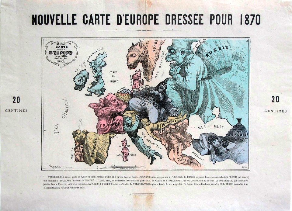
19th-century satirical maps
1878 in art
19th-century maps of the black sea
g. h. swanston
gemeente atlas van nederland - south holland
1860s maps of south holland
gemeente atlas van nederland - south holland
maps of veur
gemeente atlas van nederland - north holland
19th-century maps of den helder
nouvelle géographie universelle, vol. xii
charles eugène perron
gemeente atlas van nederland - south holland
maps of den bommel
eran laor cartographic collection
edward weller
gemeente atlas van nederland - south holland
maps of groote lindt
gemeente atlas van nederland - south holland
1860s maps of south holland
eran laor cartographic collection
edward weller
gemeente atlas van nederland - south holland
maps of koudekerk aan den rijn
19th-century maps of south holland
maps of veur
gemeente atlas van nederland - gelderland
netherlands in the 1860s
gemeente atlas van nederland - south holland
1860s maps of south holland
gemeente atlas van nederland - north holland
bennebroek
gemeente atlas van nederland - south holland
1860s maps of south holland
19th-century maps of the black sea
1870s maps of the caucasus
301 - 400 of 928
Next page
/ 10